BHARATSPECTRAL DSSI Slide 1: Beyond Human Sight
01 / 19

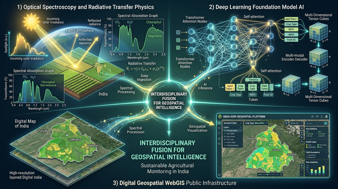
BharatSpectral: Democratized Spectral-Semantic Intelligence

Hyperspectral Earth Observation Satellite
Canopy Optical Scattering & Physics
Continuous Hyperspectral Spectroscopy
Indian Hyperspectral Coverage & Agricultural Mosaic
Democratized Edge Mobile WebGIS

Project Objectives

  • Data Acquisition & Benchmark Creation: Ingest heterogeneous hyperspectral cubes across AVIRIS-NG India (425 bands), ISRO HysIS (220 bands), and NASA EMIT (285 bands) to construct BharatHSI-Bench — India's first open, labeled smallholder agricultural benchmark dataset with standardized evaluation protocols.
  • Empirical Failure Proof: Rigorously evaluate global Foundation Models (SpectralGPT, HyperSIGMA) and baseline architectures directly on BharatHSI-Bench, quantifying severe domain-shift degradation (15%–30% Overall Accuracy drop) caused by fragmented Indian farm plots and multi-crop intercropping.
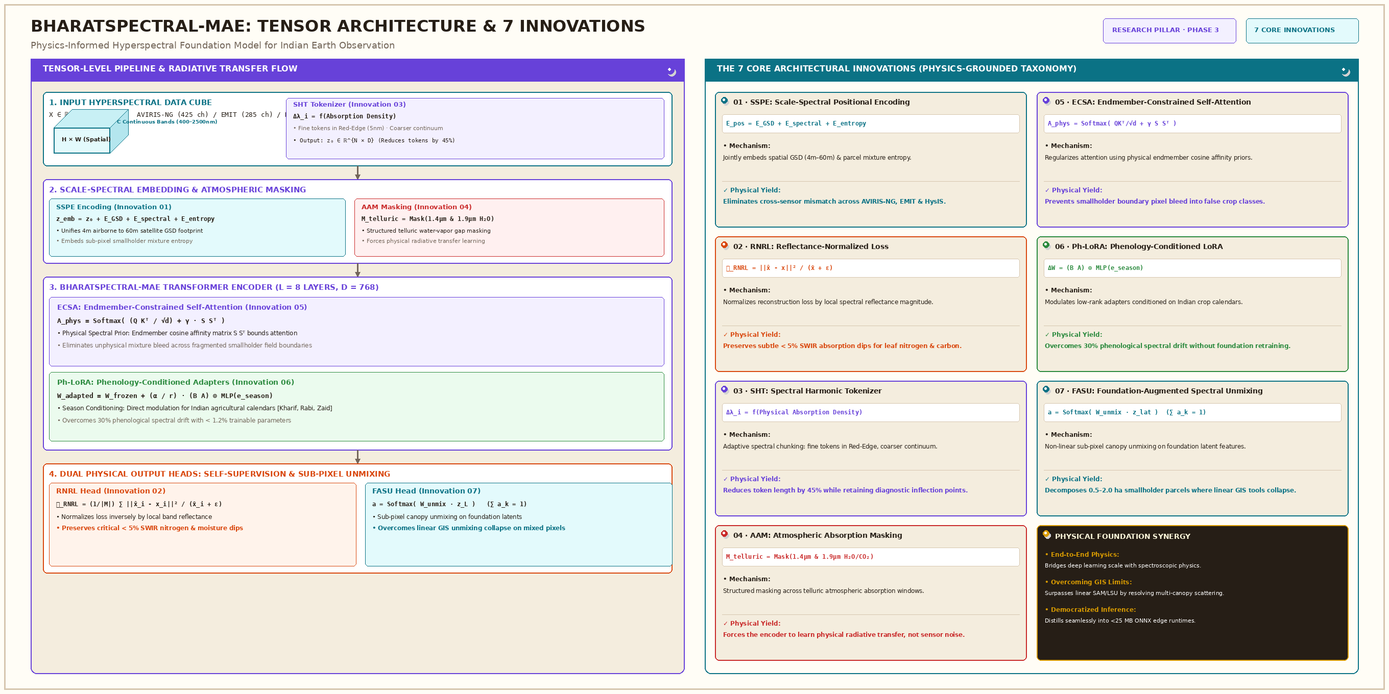
  • Physics-Informed Foundation Model: Pre-train BharatSpectral-MAE incorporating 7 named architectural innovations (SSPE, RNRL, SHT, AAM, ECSA, Ph-LoRA, FASU) to overcome non-linear canopy scattering, spatial-spectral heterogeneity, and multi-season phenological drift.
  • Comprehensive Evaluation & Ablation: Benchmark BharatSpectral-MAE against state-of-the-art foundation models and classical baselines on BharatHSI-Bench, conducting systematic ablation studies to isolate the empirical contribution of each named architectural module.
  • Model Distillation for Edge Inference: Architect a model distillation pipeline compressing BharatSpectral-MAE into lightweight ONNX student representations, enabling sub-second Serverless Spectral Inference (SSI) under strict compute and memory constraints.
  • Democratized WebGIS Deployment: Deploy the distilled inference engine within an open, zero-egress public WebGIS platform (Cloudflare R2 + Workers + MapLibre GL JS) to deliver biochemical-grade spectral analytics as sovereign Digital Public Infrastructure for non-specialist users.

The Web of Fields: Interdisciplinary Convergence

The Web of Fields: 7-Field Interdisciplinary Venn Diagram
SPECTRAL PHYSICS

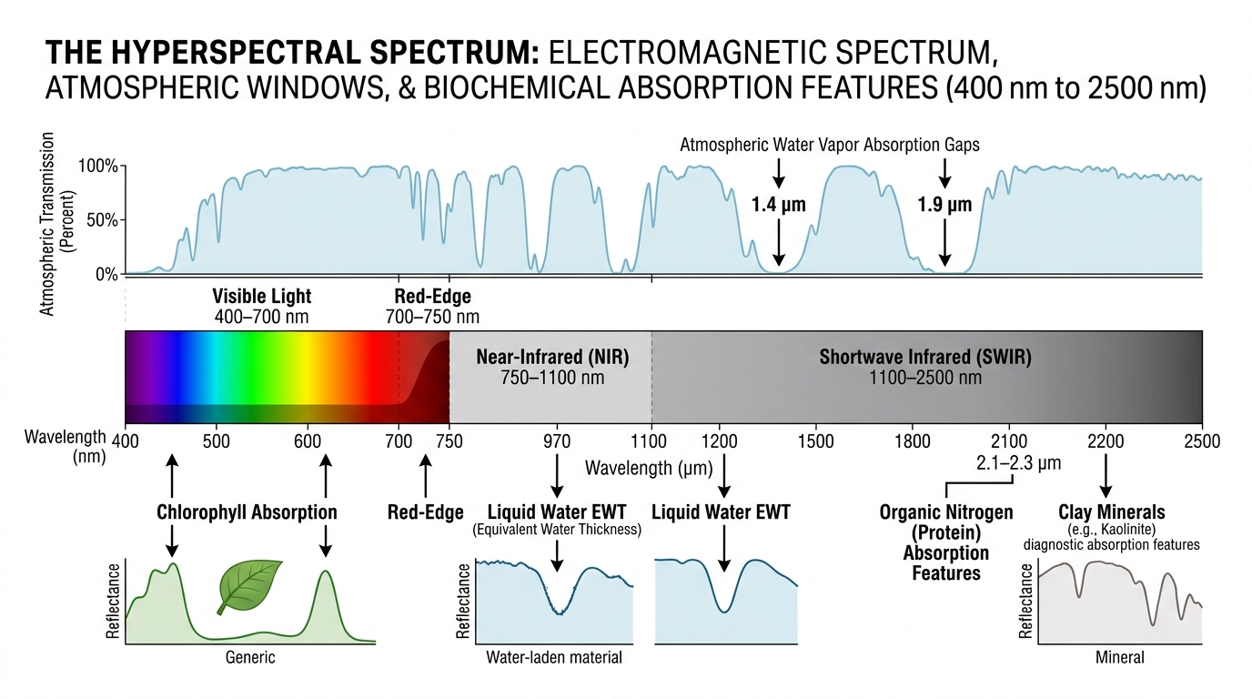
Continuous Spectroscopy: What Each Spectral Band Captures

Narrow-band molecular absorption physics across VNIR, Red-Edge, NIR, and SWIR regimes

Continuous Reflectance Signature
Continuous Spectroscopy Curve
ARCHITECTURAL INNOVATIONS SEEDED
Diagnostic Absorption Physics
  • 400–700 nm (VNIR): Plant pigment absorption (Chlorophyll a/b, Carotenoids).
  • 700–750 nm (Red-Edge): Steep cellular structure cliff. NOTE: SHT (Spectral Harmonic Tokenizer allocates fine tokens here).
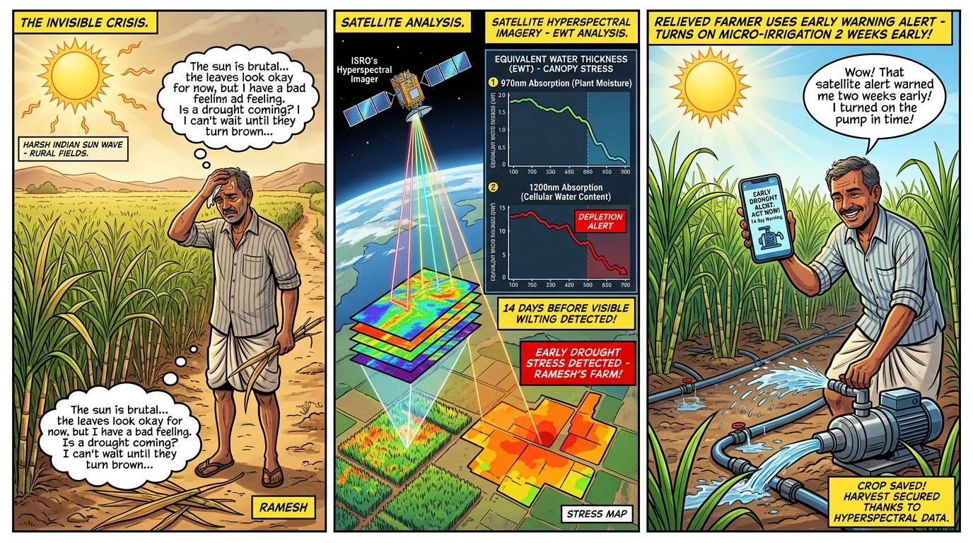
  • 970 & 1200 nm (NIR): Cellular liquid Equivalent Water Thickness (EWT).
  • 1.4 & 1.9 Ξm: Atmospheric water vapor zero-transmission gaps. NOTE: AAM (Atmospheric Absorption Masking).
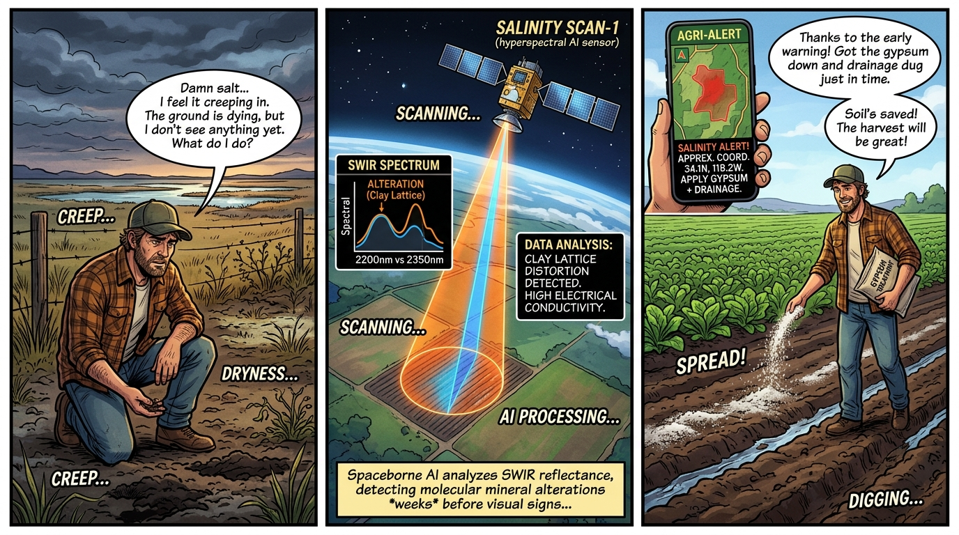
  • 2.1–2.3 Ξm (SWIR): Organic protein nitrogen, soil organic carbon (SOC), clay mineral lattices.
CANOPY RADIATIVE TRANSFER

The 'Pinball Machine' Physics: Non-Linear Scattering & 3D Pixels

Why multi-tier Indian smallholder canopies require 3D tensor foundation representations

Canopy Ricochet vs. 3D Data Cube
Photon Pinball & 3D Cube
PHYSICAL BREAKDOWN
Why Monoculture Assumptions Collapse
  • Multi-Bounce Scattering: Sunlight enters intercropped sorghum + pigeon pea and ricochets between leaves and soil before sensor reception.
  • Failure of Linear Unmixing: Classical GIS (LSU/FCLS) assumes linear superposition (r = Σ ai ei). Ricochets cause non-linear cross-talk (RMSEA > 0.15).
  • NOTE: SSPE Scale-Spectral Positional Encoding: Jointly encodes GSD (4–60 m), bandwidth, and mixture entropy.
  • NOTE: FASU Foundation-Augmented Spectral Unmixing: Decomposes complex non-linear canopy mixtures using pretrained foundation representations.
DATASET FOUNDATIONS ● PHASE 1 COMPLETE

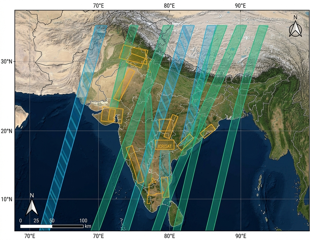
Open Hyperspectral Corpus over the Indian Landmass

Curated heterogeneous dataset harmonizing airborne AVIRIS-NG India, spaceborne ISRO HysIS, and NASA EMIT

India Coverage Map
CORPUS HARMONIZATION
Sensor Heterogeneity & Coverage
  • AVIRIS-NG India: 425 continuous bands (380–2510 nm), 4–8m GSD flightlines over Anand (Gujarat), Godavari Basin (AP), and Punjab tracts.
  • ISRO HysIS: 220 bands (VNIR/SWIR), 30m spaceborne GSD.
  • NASA EMIT: 285 bands (381–2493 nm), 60m GSD on the International Space Station.
  • NOTE: RNRL Reflectance-Normalized Reconstruction Loss: Prevents gradients from collapsing in low-reflectance SWIR bands (<5% reflectance).

Preprocessing & Physical Normalization Pipeline

01 â€Ē RAW CAPTURE Raw Earth Feeds Captured scans from satellites & aircraft Noisy & Distorted Feeds 02 â€Ē HAZE REMOVAL Strip Atmosphere Removes air haze, dust & solar glare distortion True Surface Reflections 03 â€Ē NOISE FILTER Cut Dead Bands Prunes water vapor gaps; keeps 200 purest channels 200 Diagnostic Bands 04 â€Ē FIELD CROPPING Smallholder Tiles Screens clouds & slices into Indian farm-size patches Uniform Farm Patches 05 â€Ē AI-READY TENSORS Clean Benchmark Standardized & indexed for instant neural training ⚡ Ready for Phase 3 AI TENSOR 1. Raw Scans Spaceborne capture → 2. Atmosphere Cleared Sun glare & haze removed → 3. 200 Pure Channels Dead noise bands pruned → 4. Farm-Scale Patches Sliced to Indian plot sizes → 5. Phase 3 AI-Ready Clean input for Model

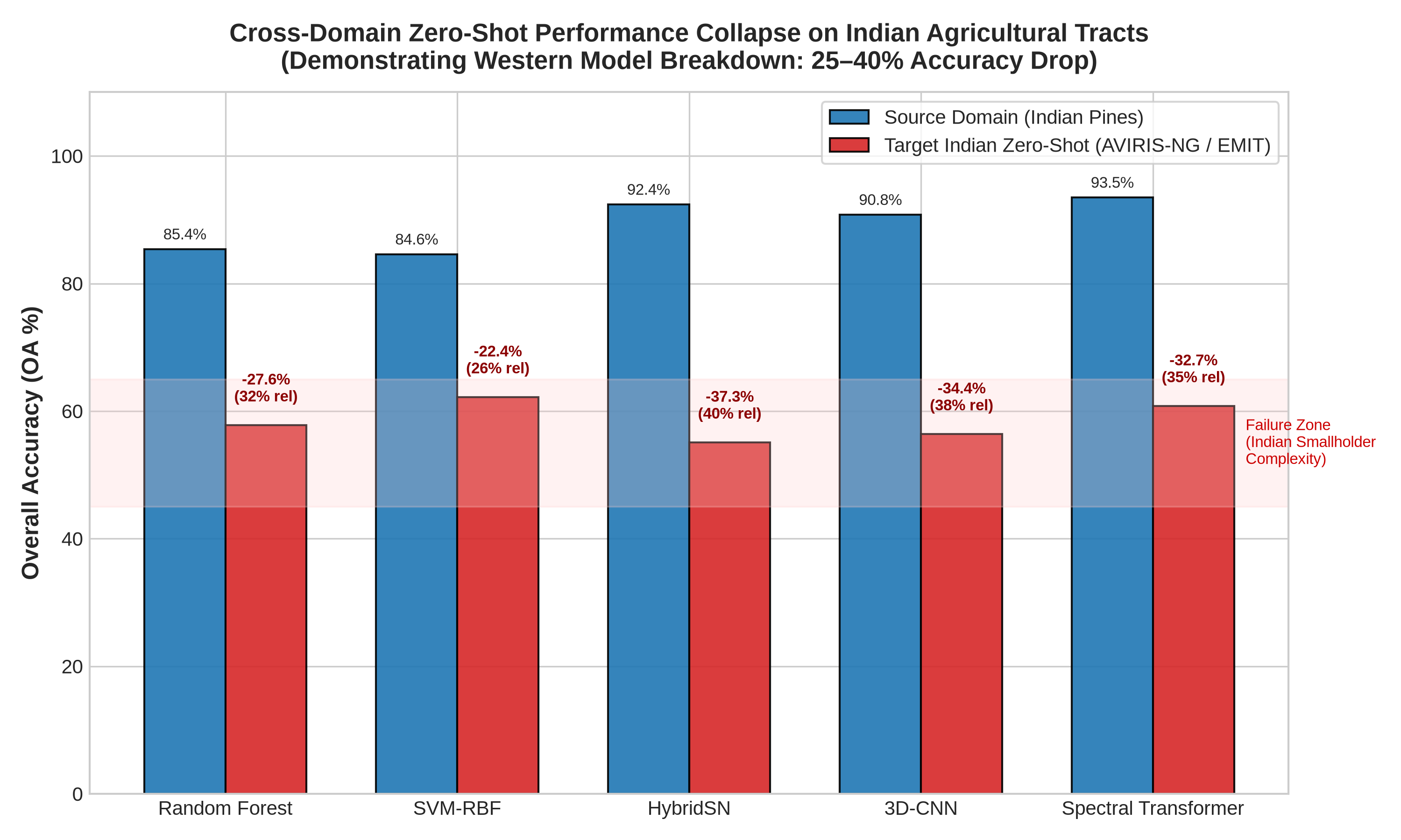
Benchmarking Previous Attempts & Foundation Models

Domain Shift Collapse (22%–37% OA Drop)
Domain Shift Collapse Bar Chart
Architecture Source OA Target OA OA Drop
Random Forest (100 Trees)85.4%57.8%-27.6%
SVM (RBF Kernel)84.6%62.2%-22.4%
HybridSN (3D-2D CNN)92.4%55.1%-37.3%
3D-CNN (Hamida et al.)90.8%56.4%-34.4%
Spectral Transformer93.5%60.8%-32.7%
SpectralGPT (Hong et al.)93.5%61.5%-32.0%
SS-MAE (Lin et al.)93.5%63.8%-29.7%
HyperSIGMA (Wang et al.)93.8%64.2%-29.6%
PHYSICAL CRITIQUE ● PHASE 2 COMPLETE

Why Existing Methods Fail in Indian Smallholder Ecosystems

Quantitative audit of physical GIS spectroscopic tools (SAM, LSU in ENVI/QGIS) vs unconstrained deep learning

GIS LSU Residuals & SAM Magnitude Blindness
LSU Residuals
SAM Magnitude Confusion
THE DUAL BREAKDOWN
Physical Tool Limitations
  • GIS SAM Baseline: Cosine angle ignores absolute reflectance magnitude, causing a 36.4% false match rate (confuses shadow/moisture with crop stress).
  • GIS Linear Spectral Unmixing (LSU): Produces high residual error ($RMSE_A = 0.2775$ on boundaries; 54.2% pixels fail threshold) due to non-linear canopy scattering.
  • NOTE: ECSA Endmember-Constrained Self-Attention: Regularizes Transformer attention weights using spectroscopic unmixing priors.
  • NOTE: Ph-LoRA Phenology-Conditioned LoRA: Modulates adapter weights by Kharif, Rabi, and Zaid phenological stage embeddings.
EXECUTION ROADMAP

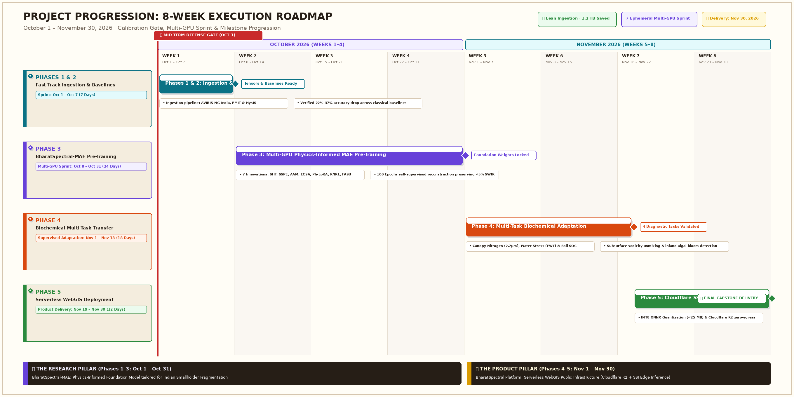
Project Progression: What is Done and The Road Ahead

Systematic milestone completion across 7th semester and active roadmap for 8th semester scaling

Project Timeline Roadmap
COMPLETED: PHASE 1 & PHASE 2

Data ingestion pipelines verified across 3 sensors; baseline architectures evaluated on Raspberry Pi 5; 22%–37% domain shift collapse empirically proven; GIS spectroscopic failure modes audited.

ACTIVE: PHASE 3 HEAVYWEIGHT FRONTIER

BharatSpectral-MAE pretraining; LoRA adapter tuning; multi-sensor harmonization; followed by Phase 4 & 5 serverless edge deployment on Cloudflare R2 + Workers WebGIS.

RESEARCH NOVELTY

The 7 Architectural Innovations: Physics-Informed Foundation Model

Formalizing BharatSpectral-MAE: Engineered specifically for Indian smallholder Earth Observation

7 Innovations Master Matrix
ANALYTIC TAXONOMY

Actionable Yield: Multi-Domain Biochemical Diagnostics

Translating continuous 425-band narrow spectroscopic signatures into 6 national public sector applications

6-Domain Diagnostic Taxonomy
PRODUCT PILLAR â€Ē DIGITAL PUBLIC INFRASTRUCTURE

From Orbit to Smallholder: Democratized Mobile Delivery

Bridging satellite spectroscopy with citizen smartphones via serverless edge browser inference

Mobile WebGIS Edge Experience
Farmer Mobile Interface
PUBLIC CITIZEN ACCESS
The Serverless Spectral Inference (SSI) Stack
  • Zero App Install: 100% web browser execution in mobile Chrome/Safari.
  • Zero Egress Cost: Cloudflare R2 stores COG tiles with $0 egress fees.
  • Edge Inference: Quantized ONNX WASM model executes sub-pixel unmixing directly inside the farmer's browser in <15 milliseconds.
  • Plain Language Advisories: Translates spectral nitrogen deficit into direct KVK advice: "Apply 12 kg Urea in Northern plot; skip Southern plot".
OPERATIONAL SCENARIO 1

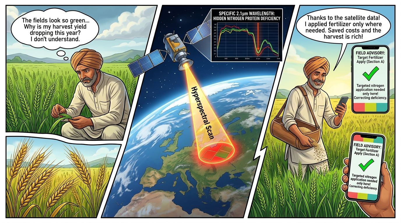
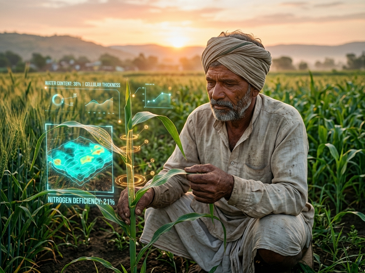
Precision Nutrient Optimization: 'The Invisible Hunger'

3-Panel Field Story: Pre-symptomatic nitrogen deficiency detection saving fertilizer costs

Comic 1: The Invisible Hunger
OPERATIONAL SCENARIO 2

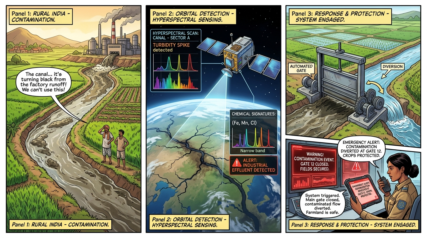
Canal Water Quality Alert: 'The Canal Lifeline'

3-Panel Field Story: Spaceborne effluent tracking and automated irrigation canal sluice gate diversion

Comic 2: The Canal Lifeline
OPERATIONAL SCENARIO 3

Early Drought Resilience: 'The 14-Day Moisture Warning'

3-Panel Field Story: Detecting 970nm & 1200nm cellular water thickness depletion 2 weeks before visual wilting

Comic 3: 14-Day Drought Warning
OPERATIONAL SCENARIO 4

Soil Degradation Defense: 'The Salinity Encroachment'

3-Panel Field Story: Subsurface electrical conductivity and clay mineral lattice tracking before salt crusting

Comic 4: Salinity Encroachment
SYSTEMS & ECONOMICS

Breaking the Barriers: Compute, Economics & Accessibility

Democratizing advanced hyperspectral intelligence across computational, economic, and knowledge dimensions

Three-Fold Democratization Slabs
CAPSTONE VISION â€Ē DEFENSE DISCUSSION

BharatSpectral: Sovereign Foundation for Indian Earth Observation

From Closed Scientific Repositories to National Citizen Empowerment
Sovereign Earth Observation Vision
ðŸŒū Food Security 💧 Water Security ðŸ›Ąïļ Climate Adaptation